What Is Flood Zone C?
6 min read · Jan 21, 2026
Flood Zone C is an older FEMA designation used on Flood Insurance Rate Maps (FIRMs) to identify areas with minimal flood hazard. They typically mark land situated outside the 500-year flood level. When the Coastal Barrier Resources Act (CBRA) was passed in 1982, it created the Coastal Barrier Resources System (CBRS) to protect fragile coastal barrier ecosystems and to prevent risky, taxpayer-funded development in storm-exposed regions. Many communities mapped during that era show Zone C areas adjacent to or near CBRS boundaries, simply because both systems were being defined and updated around the same time.
While CBRS areas restrict federal financial assistance, Zone C itself does not indicate any such restriction. It only reflects FEMA’s flood-risk classification. Together, though, they often appear on the same maps, giving homeowners a sense of which regions are federally protected for conservation, and which carry low to moderate flood risk – but not zero.
Flood Zone C Risk Profile: How Low-Risk Really Works
When we say, “minimal hazard,” we don’t mean “no hazard.” Zone C properties remain at risk, though at a reduced level. Several common triggers can still lead to flooding:
- Heavy rainfall or sudden downpours, especially if storm drains or local drainage systems are overwhelmed.
- Aging infrastructure or blocked culverts, which can’t always handle unexpected water volume.
- Localized ponding and runoff, particularly in low-lying patches, gentle valleys, or older subdivisions with poor drainage.
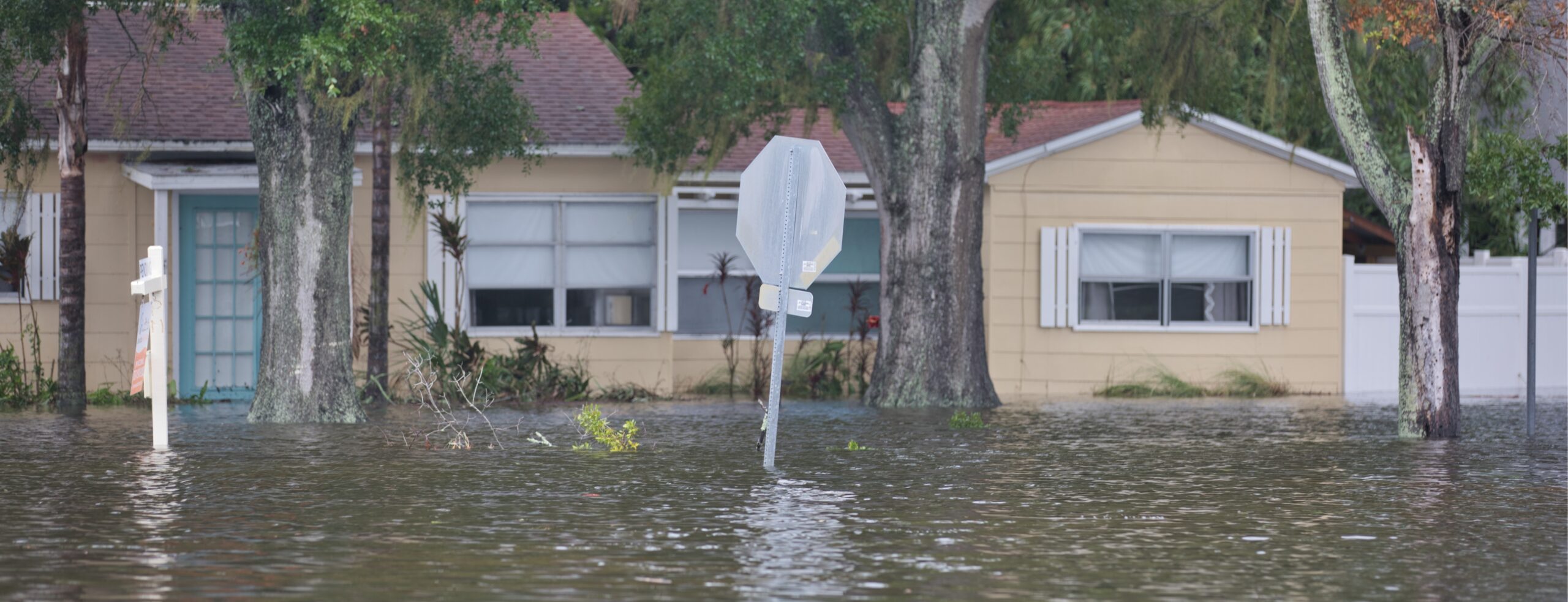
Even though Zone C is outside what are called Special Flood Hazard Areas (SFHAs), historical claim data indicates a noticeable portion of flood-related insurance claims come from these “low-risk” zones. It is a reminder that lower risk doesn’t eliminate the possibility of floods.
So, though living in Zone C offers a reduced chance of major flooding, you shouldn’t treat it as risk-free. Especially with unpredictable weather, shifting rainfall patterns, and changing land use, what was once “safe” can still experience damaging floods.
Flood Zone C on FEMA Maps: How to Identify Your Zone
If you want to know whether your property falls in Zone C, here’s how to check:
- Visit the official FEMA Flood Map (FIRM) for your community.
- Enter your address or parcel number to locate your property on the map.
- Look at the zone code label. If it says “C” (sometimes shown as “Zone C or X (Unshaded)”), or simply “X (unshaded)” on newer maps, that indicates minimal hazard territory.
- Cross-check the map’s legend to confirm the shading and risk designation.
To be noted: Because maps gradually update, it’s possible your area was once labeled Zone C but now shows “Zone X (unshaded).” That’s often just a map legend modernizing, not a change in flood risk.
If you’re evaluating a property, especially when deciding to buy, double-check the map’s effective date. Updating flood maps can shift designations even if the physical ground hasn’t changed.
For more on reading these maps, refer to our guide on Flood Insurance Rate Maps (FIRM).
Flood Zone C vs. Other Flood Zones
To understand how Zone C fits into the bigger flood-zone picture, here’s a quick comparison of common FEMA designations:
| Zone | Risk Level/Notable Features |
|---|---|
| Zone A/AE | High risk – 1% annual flood chance (100-year floodplain). SFHA; many lenders require insurance. |
| Zone V | High-risk coastal – flood plus wave velocity, surge, and storm-wave hazard. SFHA. |
| Zone B/X (shaded) | Moderate risk – between 100-year and 500-year floodplains. Some risk of shallow flooding. |
| Zone C/X (unshaded) | Minimal risk – above 500-year floodplain. No BFE (Base Flood Elevation) assigned; flooding is possible only under unusual/local conditions. |
Over time, many maps have replaced Zone C with “unshaded Zone X.” That doesn’t change the risk level. It’s still minimal hazard territory outside SFHA. Understanding these labels helps homeowners, buyers, and real estate professionals interpret risk more accurately.
Common Misconceptions About Flood Zone C
“Zone C areas never flood unless there’s a hurricane.”
Many Zone C claims come from ordinary, non-storm events, such as a clogged retention pond, a blocked culvert, or a stalled summer thunderstorm that unloads 3 to 5 inches of rain in an hour. Most residents don’t associate “sunny day flooding” with low-risk zones, yet it happens.
“If FEMA marked it as Zone C once, it’ll stay that way forever.”
Homeowners often assume the zone is permanent. Updated topography, new development, altered drainage systems, or revised coastal models can reclassify land. Zone C can move into a higher-risk category without any major disaster ever occurring.
“Local building codes guarantee that Zone C homes are safe from overflow.”
Many Zone C neighborhoods were built decades before modern elevation or drainage standards. A home may sit in Zone C but still have low-lying driveways, aging stormwater drains, or improperly graded lots that funnel water straight to the foundation.
“If the neighbors never had a flood, the whole block must be safe.”
Flood behavior is hyper-local. One home can take on water while the house three doors down stays dry, especially in areas with uneven elevation, outdated gutters, or mixed soil types. Personal anecdotes can be completely misleading.
“Flood insurance won’t pay out in low-risk zones because the risk is too small.”
Some homeowners believe insurers deny claims in “minimal hazard” areas. But payouts are based on actual flood damage, not the printed zone. Low-risk zones file thousands of claims nationwide every year, and they’re eligible just like any other zone.
Is Flood Insurance for Flood Zone C Mandatory?
In most cases, no, especially if you have a conventional mortgage and the property is in Zone C. Lenders rarely mandate it because Zone C is outside the SFHA.
That said, “not required” doesn’t mean “not worthwhile.” Nationwide data from the National Flood Insurance Program (NFIP) has repeatedly shown that a surprising share of flood claims actually come from moderate- and low-risk zones like Zone C. In other words, the map may label the risk as minimal, but homeowners in these areas still experience costly water damage, often from overflow, drainage issues, or intense local storms.
If you value financial protection for your home’s interior, belongings, and long-term resale strength, having flood insurance for a flood-zone property is still a smart move. And because flood Zone C areas are considered low-risk, rates from both the NFIP and private flood insurance policies are usually far more affordable, giving homeowners a practical safety net without a heavy financial commitment.
Get a personalized flood insurance quote because even in low-risk zones, coverage can often be more economical than many expect.
FAQs
Is Flood Zone C considered a safe zone?
It’s considered a minimal hazard zone, meaning risk is low but not zero. Flood Zone C is safer than high-risk zones, but localized flooding from heavy rain or drainage issues can still occur.
Can Flood Zone C change to updated maps?
Yes, especially as map legends evolve. Many newer maps relabel Zone C as unshaded Zone X. That doesn’t inherently increase or reduce flood risk, but it’s wise to re-check your property’s status when maps update.
Is Zone C the same as Zone X?
On older maps, “Zone C” was used. In newer Flood Insurance Rate Maps (FIRMs), “unshaded Zone X” usually corresponds to what was once Zone C, but both indicate minimal flood hazard.
Do renters in Zone C need flood protection?
If you rent in Zone C, flood insurance isn’t required, but having a contents policy can be very wise. Even minimal water intrusion can damage floors, walls, and personal belongings. A moderate-cost policy may save you major hassle later.
